
Circular Walk through Allardsoog |Koningspad XL Hiking Trail Network: Section 1
This section of the Koningspad XL Hiking Trail Network leads you through the area from where the Koningsdiep river first sprang. The river is also known as It Alddjip and De Boarn. The route starts at the restaurant on the De Slotplaats country estate. You walk across the It Mandefjild heath to the area of heathland near the hamlet of Allardsoog on the border between the provinces of Friesland and Drenthe. The return leg of the walk takes you past Puppedobbe pond and the Bakkeveenster Duinen dune reserve as you make your way back to De Slotplaats in Bakkeveen.
The 14 sections of the Koningspad XL Hiking Trail Network take you past the highlights of the Koningsdiep stream valley. A journey through meadows, heaths and the open landscape of Friesland.
To find out m…
This section of the Koningspad XL Hiking Trail Network leads you through the area from where the Koningsdiep river first sprang. The river is also known as It Alddjip and De Boarn. The route starts at the restaurant on the De Slotplaats country estate. You walk across the It Mandefjild heath to the area of heathland near the hamlet of Allardsoog on the border between the provinces of Friesland and Drenthe. The return leg of the walk takes you past Puppedobbe pond and the Bakkeveenster Duinen dune reserve as you make your way back to De Slotplaats in Bakkeveen.
The 14 sections of the Koningspad XL Hiking Trail Network take you past the highlights of the Koningsdiep stream valley. A journey through meadows, heaths and the open landscape of Friesland.
To find out more about this section of the network, take a look at the detailed description of the route with photos and videos.
Sights on this route
Starting point:
Waypoint walk 55
Bakkeveen
Navigate to starting point
Waypoint walk 55
Bakkeveen
Navigate to starting point
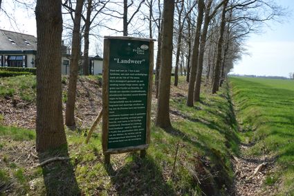
Landweer Allardsoog
Vlakbij Allardsoog op de Fries-Drentse grens vind je een Landweer. Dit rijksmonument was een verdedigingswerk om plunderaars buiten de deur te houden.
Uitkijkpunt Bakkeveen
Een prachtig uitkijkpunt nabij de duinen van Bakkeveen. Vanaf hier kijkt u ver over het prachtige natuurgebied. De Belvedere is 23 meter hoog en is geopend op 22 juli 2005. Het Bakkeveense uitkijkpunt is gratis toegankelijk.

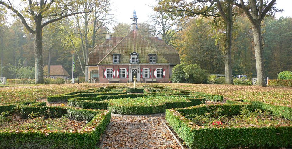
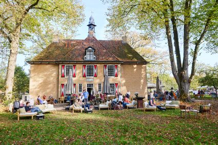
De Slotplaats
De Slotplaats in Bakkeveen, Inspiration Location, Dining, Weddings, Meetings, Events
End point
De Slotplaats
9243 JZ Allardsoog
Navigate to endpoint
Directions
Starting point:
Waypoint walk 55
Bakkeveen
Navigate to starting point
Wandelknooppunten: 55 - 69 - 68 - 43 - 47 - 58 - 52 - 56 - 54/51 - 53 - 40 - 44 - 16 - 66 - 62 - 50 - 58 - 78 - 47 - Vervolgens Witte Singel volgen tot aan de rand van het bos, RA achter camping Wâldsang langs. Na de camping het eerste pad LA naar de Burmaniazuil|Slotplaats in het verlengde van knooppunt 55.
- 55
- 55
- 69
- 68
- 43
- 47
- 58
- 52
- 56
- 54
- 51
- 53
- 40
- 44
- 16
- 66
- 62
- 50
- 58
- 78
- 47
- 40
- 55